Blogging from Kaingaroa

April 29, 2005

Rugby Blues

When I got to Auckland from the SI, I finally got to see a live rugby game. I am finally starting to get a rough idea of the game, although it still gets confusing at parts. It is even tougher because there are several different versions: Union, League, Sevens, plus that Australian rules game. A bit like soccer because the ball keeps moving; a bit like football since it looks like a football, they throw it, and they tackle each other. No forward passes though.

Anyway, it was a good game; the home team Blues upset the Brumbies from Australia. Actually, the dominated. It was 27 to 5 or something. The crowd had noisemakers and did the Mexican wave, just like home. There was also a kiss-camera and a mid-game, jumbotron marriage proposal as well. (She said yes.) Overall, it is a pretty good sport -- certainly better than the other ones they play here.

April 25, 2005

ANZAC Day

Today is ANZAC Day, which is like Veteren's Day. ANZAC means Australia-New Zealand Army Corp. In both World Wars they fought as a combined force. It is April 25th because that is the anniversary of the Gallipole battle in Turkey during WWI. It was an amphibious assault, sort of like D-Day, and even though the Turkish force was small, the ANZAC forces suffered a 88% casualty rate. I don't know the numbers, but Kiwis enlisted at very high rates in both World Wars, so it is a very big deal here.

Milford Sound

After completing the Kepler Track, I visited the famous Milford Sound in Fiordland. This area is the most rugged and remote in New Zealand. The southwest coast of the South Island is puncuated by a series of huge fiords carved out during the last ice age. Milford is the most famous because it is the steepest and narrowest. Some of the mountains rise almost vertically out of the ocean to an altitude of one mile. This picture is of the entrance of the sound from the Tasman Sea. Those peaks are at the same altitude as Denver, but directly on the ocean.


Posted by Hello

Milford Waterfall

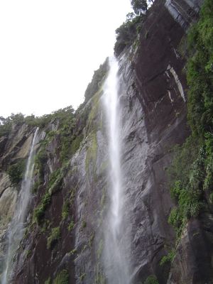
Despite the fact that the walls of Milford sound are sheer rock, there are still lots of plants and trees growing on the surface. There are also a number of waterfalls, some over 500 feet high. It's strange when a 500 foot waterfall looks small tracing a line down a 5000 foot cliff. This picture is not the biggest fall there, but I liked it anyway.


Posted by Hello

Milford Dolphins

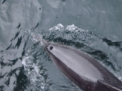
One fun bonus in Milford was that we saw more dolphins. The captain said they see dolphins about 3 times a month, so I was lucky. They like to surf in the bow wave of the boat and they stayed with us for a good while, skimming along just below us. I was also lucky not to get rained on. This region is one of the rainiest in the world. (That's over 21 feet of rain a year in Milford.) Although it was a grey day, and there were some sprinkles in the morning, the cruise was dry.


Posted by Hello

Walking Across New Zealand

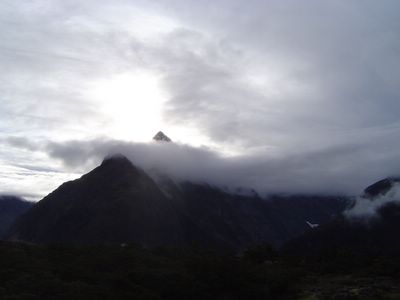
After the Milford cruise, the rest of the yokels hopped on the bus for the six hour drive to Queenstown, but I decided I would walk it instead. Well, actually I took the bus up through the Homer Tunnel and to The Divide before I started walking. And I really only went to Glenorchy and took a boat to Queenstown. But I still walked a far piece. On the first day, the weather was rather threatening, but it never turned against me, instead providing some atmospheric views of the the Southern Alps. Like this.


Posted by Hello

Caples Tarn

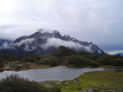
Walking on the Caples Track brings trampers to a lot of tarns, or mountain top lakes. It is surprisingly boggy for the altitude and steep slopes. It is partly due to lots of rainfall, and partly due to the rocky ground not absorbing any water. After crossing the McKeller saddle, the walk descends into a valley and tracks the Caples River for several miles before finally ending at Lake Wakatipu. The photo is of a tarn on the saddle. On this track I ran into a couple of Hawaiins that I had met a week earlier, while touring the Catlins. There weren't that many people on the track or on the bus tour, so it was a surprising coincidence.


Posted by Hello

Routeburn

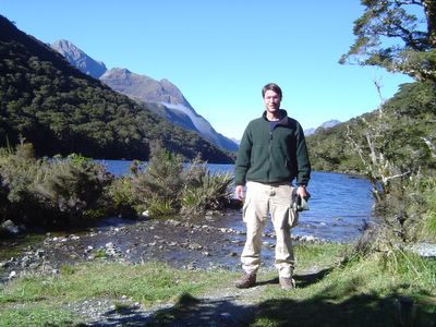
In walking to Glonorchy, I started along the Routeburn Track, which is one of the Great Walks, and then slid down to the Caples track for the majority of the trip. Apparently, somewhere along the walk, I morphed into a giant, as seen in this picture from the front steps of the Howden Hut. "Hello tiny trees! Your mountains are but small boulders to me!"


Posted by Hello

Queenstown and Hang Gliding

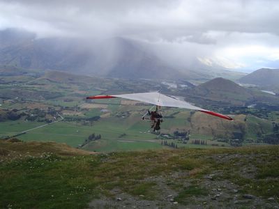
After my tramping, I went to Queenstown, the "adventure capital of New Zealand." It is in a gorgeous location, along the pristine Lake Wakatipu and surrounded by the Remarkables mountains. It has become the downunder Vail for some Hollywood types. However, it is highly tourist oriented, with a major focus on bungi jumping, sky diving, jet boating, etc. My hostel was "Bungi Backpackers". I didn't go all-out like that, but I did go hang-gliding, which was a fantastic experience. We got airborne quite easily, although there was not enough sun to have a really good or long flight. It was a tandem flight, but I got to take the controls for a little bit. I really do not have the gist of it yet. It is very quiet and peaceful to glide along, but the pilot also threw in some spins and tricks that woke me up. That is not me in the picture, since I took the shot, but I did the exact same thing. You can see there were some rain cells, but still decent visibility. Lots of fun.


Also in Queenstown, I bumped into this German guy who I had seen in Christchurch and then was on the same tour with in Dunedin. While tourists do tend to do a loop of a lot of the same cities, it was still quite a coincidence to see someone on the streets of three different cities that are a good distance apart, and several days apart. Small country.
Posted by Hello

April 20, 2005

Didgeridoo

Today I played a didgeridoo for the first time.

April 18, 2005

Mt. Luxmore

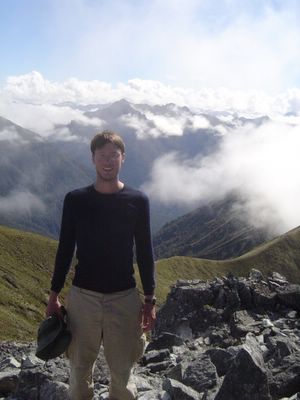
This is me on Mount Luxmore, the highest point on the Kepler Track, and those are the Southern Alps all around. The second day of the track was almost entirely across a series of ridge tops, and yes parrots live up here. The morning was very cloudy and atmospheric, with a sea of white being pierced by black rocks, both across the valley and in the far, far distance. Around the time I reached the top of Luxmore, the sky started to clear and I could see all of the
mountain ranges, plus I could look straight down onto Lake Te Anau and Lake Manpouri. I had intended to keep moving, but I ended up sitting up there for a couple hours, taking in the view. I also got to meet an Iraq War veteran and hear a bit about that. The day yielded a number of good pictures, but I will limit myself to one that features everyone's favorite subject: me.


Posted by Hello

Kepler Rain Forest

After the alpine section, I was mostly walking through some fantastic beech forests. I still can't get over what a rain forest it is, even though it is quite far south.


Posted by Hello

Pukeko and Other Birds

The Kepler was also good for bird-watching. I saw my first riflemen on this walk. They are funny to watch because their wings seem too small for their body and they have almost no tail. I also saw the one and only yellowhead I have seen in New Zealand.

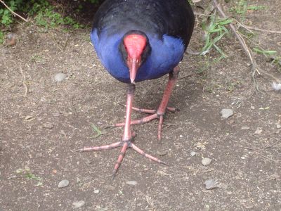
The Kepler yielded the single best photo of a tomtit that I have gotten. There were also lots of fantails and a few kereru. This picture, though, is from the bird center in Te Anau. It is a semi-wild pukeko. It uses those big feet to get around on swampy ground.


Posted by Hello

Tomtit in a Sea of Green

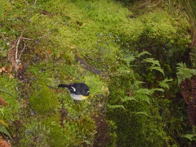
Here is a tomtit on the Kepler Track. The ones on the South Island have a bit of yellow, as you can see. They are tiny little insect catchers and they are not too shy around people.

Posted by Hello

April 17, 2005

Hello Birdie

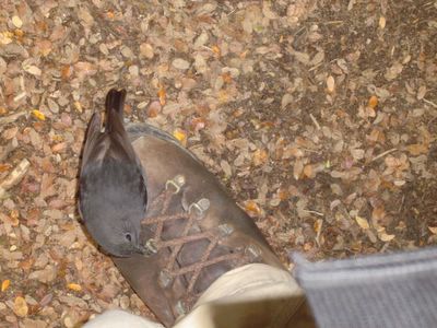
I wasn't kidding when I said that New Zealand birds are not shy. This robin hopped along the path and stopped just to make sure my shoelaces weren't some new kind of tasty worm before hopping along again.


Posted by Hello

Auckland Skyline

After finishing in Queenstown I flew to Auckland before touring Northland. While Queenstown was getting to be a bit cold, even on sunny days, it is still summer in Auckland. I put all my fleeces into storage since they won't be necessary. Auckland is not a bad city. It certainly has extensive eating options, especially asian food. Here is an evening view from Devonport, with the Sky Tower being the most obvious building. It is slightly higher than the Eiffel Tower.


Posted by Hello

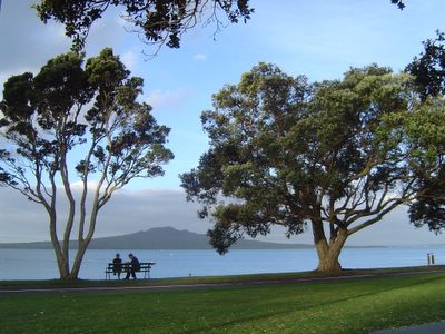
Rangitoto

Auckland is surrounded on all sides by volcanoes, although they are generally quite small and inactive. The biggest is Rangitoto Island, which was formed just 600 years ago by an eruption witnessed by Maori. It is just offshore and easily accessible by ferry, which I plan to do at some point.


Posted by Hello

Waipoua and the Kauri Coast

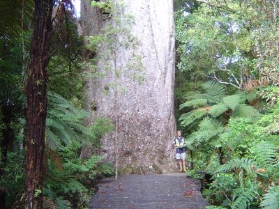
When I headed north, I spent a night in Waipoua so I could see some of the kauri trees there. These trees are simply massive, as you can see in this picture. That's a guy I met who does forestry research and likes to look at trees in his spare time. He said this one tree held at least $500,000 worth of timber. Some of these trees are as wide as a two lane road and when Maori arrived, some were as wide as a four lane road. The kauri trees grow perfectly straight and with no low branches, so they were perfect for making ship masts and Europeans cut down entire forests until almost all were gone.

Now, the trees are protected, but people still dig them out of the ground. Apparently some event 45,000 years ago destroyed and buried vast kauri forests. Even after that time, the timber is perfectly good. The Kauri Kingdom has a spiral staircase entirely inside a tree and they have a couch carved from a single kauri stump for $40,000. Besides the timber, kauri also produce a gum (sap) that was used for varnishes and other products. It was also used as an artistic medium. Digging up gum nuggets of up to several hundred pounds became a major industry for several decades in Northland.


Posted by Hello

Omapere, Opononi, and Hokianga

After Waipoua, I visited Omapere on the Hokianga Harbor, which is onthe west coast of Northland. The biggest sites here are The Dunes, where you can go sandboarding, and the Opo museum, where you can learn about Opo the Friendly Dolphin. Beyond that, it is a beautiful and relaxing spot. Originally, I intended to pass straight through, but I missed my bus and was forced to stay here, which turned out to be great fortune.

Cape Reinga

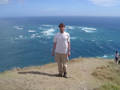
After Omapere, I did the obligatory trip up to Cape Reinga. It is the most northern spot in NZ with a road. Apparently, you can get a smidgen further north, if you have a helicopter, but this was close enough for me. It was perfect weather, for the 30th straight day, although this was a mixed blessing. The Cape is the spot where the Tasman sea (on the West/left) and the Pacific Ocean (on the East/right) join together. The Tasman is much more green and the Pacific is blue. The currents run in opposite directions, creating a froth of crashing waves out in the ocean, which is great to watch. Apparently, this scene is turned into a boiling maelstrom during winter storms, but I will gladly take the nice weather we had.


Posted by Hello

The Jumping Off Point

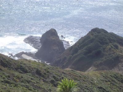
Also on Cape Reinga, there is a tapu Maori site. The tradition is that when Maori die, their spirits travel to the northern tip of Aotearoa, and then enter a pohutakawa tree, which serves as the bridge to the afterlife. Spirits reach the tree, enter the ocean, and travel to the Three Kings Islands, which are just a few k's away, and then somehow reach the spirit world. That is the tree, on the right side of the rock in the middle of the picture.


Posted by Hello

90 Mile Beach and Sand Boarding

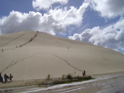
On the return from Cape Reinga, we went sandboarding down some huge sand dunes, which was some great high-speed fun. From there, the route south took the bus onto 90 Mile Beach (which is 64 miles long, obviously). The beach is actually the main highway on the west coast of the far north, although it is not passable near high tide. It made for a full, fun day.


Posted by Hello

April 05, 2005

Kepler Track

One facet of the Kepler Track that I enjoyed is that the middle section is all alpine territory. For all my time in New Zealand, this was the first alpine area I had seen. This afforded some stunning views of the Southern Alp mountain ranges. It also gave me my first view of a wild Kea. The kea is the world's only alpine parrot. Of course, we think of parrots as jungle creatures, but these ones live above the tree line in rather cold conditions. They are famous for being very smart, which also makes them troublesome. They damage cars and camping gear that are unattended and they are very good at stealing food. Their feathers have a dark outline, which helps you see each feather, but it also gives them a sort of artifical appearance. It is an eye-catching look, which is further boosted when they fly and reveal the bright orange that is hidden under their wings. I did get one photo, but it is not that good.

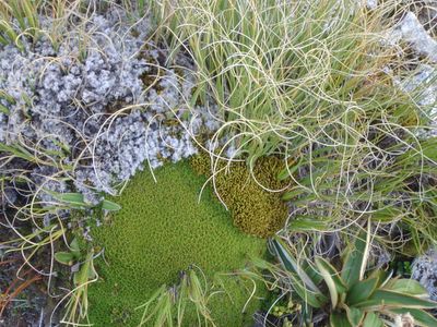
In addition to the birds, I saw a lot of plant life that I had not seen before. From a distance, the treeless landscape looks dull and almost barren, but there was a wide variety of shrubs, mosses, lichens, grasses, and so on that are quite beautiful. Here is a picture.


Posted by Hello

Slope Point

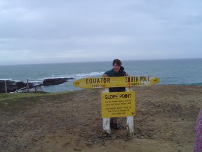
Another point worthy of a visit is Slope Point, which is the most southern spot on the South Island. (There is still Stewart Island south of that, and a few other pinprick islands closer to Antartica that New Zealand
controls.) It is almost 47 degrees south, which is not quite as polar as the US-Canadian border at 49 degrees.


Posted by Hello

Petrified Forest

Another famous spot in the Catlins is the Petrified Forest. 120 million years ago a forest in this spot was covered by volcanic ash and then petrified. Now, wave action has uncovered this spot and you can see the trees where they fell during the cataclysm. It is a famous, popular spot, but to be honest, this was one of the few times I have been underwhelmed here. The stone really does look a lot like wood; you can see the wood grains, but I was more interested in the yellow-eyed penguin I spotted or even the snails on the rocks.


Posted by Hello

Nugget Point

After I left Dunedin, I took a bus tour of the Catlins coast which is the southern coast of the South Island. It is famous for a wild and rugged landscape and is not visited as much as the more famous spots because it is less accessible, although roads are being
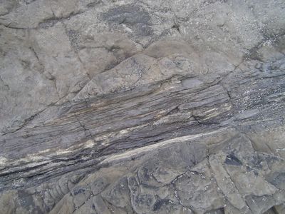
improved. One famous spot to the east is Nugget Point where a number of large rocks stretch out from a point. I don't know if it will be clear on the website, but these rocks have all been rolled 90 degrees somehow so that all the rock layers now run vertically instead of horizontally.


Posted by Hello

April 02, 2005

GRE

Whew. I took the GRE Biology test this morning. Apparently, in all of New Zealand, nine (9) people took the GRE in the [northern] spring of 2005. I think it went fine. There were a few topics that came up that were not on the practice test, especially population ecology and paleontology, but I don't think it was a major problem. I was also bothered by how many of answers were "B". At one point I had 6 Bs in a row. But I think I did pretty well overall. And it is over now. Yay.